Government of IndiaGOVERNMENT OF INDIA
Skip main content
English language
Accessibility
Accessibility Tools
Color Adjustment
Text Size
Navigation Adjustment
Screen Reader iconScreen Reader
MyGov Twitter
MyGov Facebook
MyGov Youtube
MyGov Instagram
MyGov Linkedin
MyGov Whatsapp
Meri Sarkar Logo

Recent Searches

      Close

      Get Involved

      • Groups
      • Do/Tasks
      • Discuss
      • Poll/Survey
      • Blog
      • Talk
      • Quiz
      • MG Prime
      • Campaigns
      • Pledge
      • Podcast
      • Media
      • Periodicals

      MyGov States

      • Andaman & Nicobar Islands
      • Arunachal Pradesh
      • Assam
      • Chandigarh
      • Chhattisgarh
      • Dadra and Nagar Haveli and Daman and Diu
      • Goa
      • Gujarat
      • Haryana
      • Himachal Pradesh
      • Jammu And Kashmir
      • Jharkhand
      • Karnataka
      • Ladakh
      • Madhya Pradesh
      • Maharashtra
      • Manipur
      • Mizoram
      • Nagaland
      • Rajasthan
      • Tamil Nadu
      • Tripura
      • Uttar Pradesh
      • Uttarakhand
      • Lakshadweep
      • Odisha
      • Puducherry
      • Sikkim

      Microsites

      • Blog
      • Campus
      • Innovate India
      • Pledge
      • Quiz
      • Saathi
      • Self4Society
      • Transforming India
      • PM Events

      Get to Know

      • MyGov: An Overview
      • Associate with MyGov
      • Work at MyGov
      • Circulars
      • Pulse Newsletter
      • Tenders
      • Weekly Newsletter
      • Meity Dashboard
      • Sectors
      • Skills
      • Area of Interest
      • Age Group
      • National Events
      • Archive Sites

      Help/Feedback

      • Contact Us
      • FAQ
      • Feedback
      • Help
      • Link To Us
      • Public Grievance
      • Site Map
      • Terms & Conditions
      • Usage of Aadhaar
      • Web Information Manager
      • ICC
      • MyGov Social
      • Points and Badges
      • Website Policies
      user-profile
      Together, Let's Engage In Good Governance 
      Login/Register
      1. Home
      2. Discuss
      3. Public Consultation Document on Intra-village Road Coding and their Grading System

      Public Consultation Document on Intra-village Road Coding and their Grading System

      Facebook X
      Public Consultation Document on Intra-village Road Coding and their Grading System
      Start Date 25/06/2026 - 16:26
      End Date 14/07/2026 - 23:59
      Time zone: IST (GMT +5.30 Hrs)
      Login to Participate
      Ministry: Ministry of Panchayati Raj
      Created : 25/06/2026
      135
      Total Comments
      76
      Users Participated

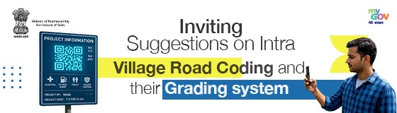
      The Ministry of Panchayati Raj, Government of India, in collaboration with MyGov, invites citizens, local communities, Panchayati Raj Institutions, experts, practitioners, and stakeholders across India to participate in a public consultation on the proposed Intra-Village Road Coding and Grading System.

      The Government of India is taking a pioneering step towards transforming the lives of millions of citizens in rural areas through Grameen Bharat. For the first time, the country will have a standardised digital system to code and grade every internal road within villages. This initiative has been conceptualised and spearheaded by the Ministry of Panchayati Raj and will be implemented through a whole-of-government approach involving multiple Ministries, Departments, and agencies working together.

      A public consultation document on the proposed Intra-Village Road Coding and Grading System has been prepared, and the Ministry invites suggestions and feedback from citizens, local communities, and stakeholders before the system is finalised.

      The Problem Being Addressed:
      India has an extensive rural road network developed under various government schemes. However, internal roads within villages have never been systematically documented or mapped, leading to several challenges:
      • Ambulances responding to medical emergencies often face difficulty locating the correct lane or pathway.
      • Postal workers and courier services are unable to navigate accurately to specific village addresses.
      • Government officials lack a reliable database for planning road maintenance and infrastructure development.
      • Emergency services such as fire and police vehicles lose valuable time locating destinations.
      • Digital maps and navigation applications are unable to provide accurate last-mile connectivity within villages.
      • Schemes such as MGNREGA, PMGSY, and PMGY cannot be efficiently monitored or implemented without proper road identification.

      Different agencies currently use different naming conventions, local landmarks are used informally, the same road may appear under multiple names in different records, and there is limited integration with modern geospatial technologies. This often results in confusion, duplication of effort, and inefficient utilisation of public resources.

      Vision and Objective:
      The vision of this initiative is that every road inside every village in India should have a unique, recognisable name and code, visible through signage, traceable on digital maps, and linked to a national database.

      The objective is to improve ease of living in rural areas by ensuring that medical, postal, administrative, commercial, and emergency services can reach any address within a village quickly, accurately, and without confusion.

      In one sentence:
      If one can be found, one can be served.

      Key Areas for Public Feedback:
      The Ministry seeks public inputs on the proposed road coding system, DIGIPIN integration, Gram Manchitra as a common platform, and PMGSY codification.

      Participants are invited to share their views on the following:
      1. Does the proposed grading and coding system (Main Roads, Crossroads, etc.) suit the needs of your village?
      2. Does the proposed system align with PMGSY’s Core Network?
      3. Are there specific challenges in your area that the system, DIGIPIN, Gram Manchitra, or PMGSY codification should address?
      4. What suggestions would you offer to ensure community participation in road coding, DIGIPIN assignment, and PMGSY code assignment through Gram Manchitra?
      5. How can signage, DIGIPIN integration, Gram Manchitra, and PMGSY QR codes be improved for better accessibility and infrastructure planning?

      Who Can Participate:
      • Citizens residing in rural and urban areas.
      • Panchayati Raj Institutions and elected representatives.
      • Local communities and village-level stakeholders.
      • Academicians, researchers, planners, and domain experts.
      • Civil society organisations and development practitioners.
      • Government officials and field functionaries.
      • Any individual interested in strengthening rural governance and service delivery.

      Why Your Feedback Matters:
      Your suggestions will help shape a nationally standardised framework for village road identification, digital mapping, service delivery, infrastructure planning, emergency response, and governance. Public participation will ensure that the proposed system remains practical, inclusive, and responsive to local realities.

      Click here for Detailed Consultation Document (Hindi).

      Click here for Detailed Consultation Document (English).
      laxmiprasad330@gmail.com
      LAXMI PRASAD BODA
      1 month 1 week ago

      The proposed system seamlessly complements the PMGSY Core Network by bridging the critical gap between macro-rural connectivity and micro-destination navigation. While the PMGSY framework provides the foundational, all-weather road infrastructure to the village periphery, this system establishes a highly structured intra-village coding network to ensure seamless last-mile service delivery. By integrating localized asset-mapping with geo-spatial utilities like DIGIPIN and Gram Manchitra, the system transforms basic physical connectivity into a high-utility routing grid. This structured addressing directly ensures that emergency medical response, postal logistics, and administrative services can navigate the final stretch to reach any specific doorstep without confusion. Ultimately, it capitalizes on public capital investments to systematically elevate the ease of living across rural communities.

      aryanverma_1355
      aryanverma_1355
      1 month 1 week ago

      I strongly support the proposed Intra-Village Road Coding and Grading System as it will improve rural connectivity and public service delivery. Every village road should have a unique code, name, and clear signboard linked with DIGIPIN and Gram Manchitra for accurate digital mapping. QR codes on signboards can provide road details and assist emergency services, postal workers, and government officials. To ensure success, Gram Panchayats should actively involve local residents, especially youth and volunteers, in identifying and verifying road names and locations. Regular updates should be made whenever new roads are constructed or existing ones are modified. The system should also support regional languages along with English to make navigation easier for everyone. This initiative will strengthen infrastructure planning, improve emergency response, reduce confusion in addressing, and enhance transparency in rural governance, contributing significantly to the vision of Viksit Bharat.

      Akshay Jain_16
      Akshay Jain
      1 month 1 week ago

      Kindly merge all the Co - Opreative Banks which are State Co - Opreative Bank, District Central Co - Opreative Bank, Scheduled Urban Co - Opreative Bank and Non Scheduled Urban Co - Opreative Bank like Regional Rural Bank because this makes the Bank Strong. From the State Level or Nationalised Level Bank it make the Bank Strong & Boost the Economy & create the Job.

      Akshay Jain_16
      Akshay Jain
      1 month 1 week ago

      Kindly merge all the Co - Opreative Banks which are State Co - Opreative Bank, District Central Co - Opreative Bank, Scheduled Urban Co - Opreative Bank and Non Scheduled Urban Co - Opreative Bank like Regional Rural Bank because this makes the Bank Strong. From the State Level or Nationalised Level Bank it make the Bank Strong & Boost the Economy & create the Job.

      Nasim Kutchi
      Nasim Kutchi
      1 month 1 week ago

      contd:- The facilities of Ambulance, market, busstop, hospitals etc. should be brought for better development inside and outside the village and for villagers, road communication should be inter connected internally with each other so that people doesn't face problem regarding recognizing the villages and their family houses. The road is one of the most important and vital aspects where villagers will get the best part to be connected with internet and with the facility of communication.

      Nasim Kutchi
      Nasim Kutchi
      1 month 1 week ago

      contd.:- A public consultation document on the proposed Intra-Village Road Coding and Grading System has been prepared, where villagers village is the first and foremost important part of out country which should be developed and addressed in some service delivery where roads shuld be attached internally, The vision of this initiative is that every road inside every village in India should have a unique, recognisable name and code, visible through signage, traceable on digital maps, and link

      Nasim Kutchi
      Nasim Kutchi
      1 month 1 week ago

      From the bottom of the soil to the top of the Sky, Villagers are the one whose tears and sweat are one of the sweetest drop of hard labour for our country india where we as a citizen of India as The Ministry of Panchayati Raj, Government of India, in collaboration with MyGov, invites citizens, local communities, Panchayati Raj Institutions, experts, practitioners, and stakeholders across India to participate in a public consultation on the proposed Intra-Village Road Coding and Grading System is

      Keerivalappil Achuthan Subhas
      Keerivalappil Achuthan Subhas
      1 month 1 week ago

      Requirement: Adequate, sufficient, user friendly, simple map for all public and citizen personal, private and commercial use. Technical, hydrological, forestry, etc specific maps stand out of present scope. Options available: Either develop in-house or use existing available maps. Recommended option: Available in-house maps like Bhuvan, etc, do not meet our requirements. So, use existing map versions. Which map: Google Maps is the best option. Existing scenario: Google maps cover all the existing roads in real time today. However, these roads are known by different names and coding like SH, NH, MDR. Other roads are not codified or notified. Even MDR category coding is incomplete. All buildings, houses, community centers, flats, apartments, hotels, cinemas, offices, etc are already covered and named. However, this list is also incomplete. Action Plan: Google has an online facility for users to name and update building names. Existing names, missing details may need updating.

      Surya Prakash_468
      Surya Prakash_468
      1 month 1 week ago

      जरूर ऐसा करना चाहिए धार्मिक सामाजिक भौगोलिक पहचान रोडो देनी चाहिए नामकरण से पहले उस के आस पास लोगों की राय लेनी चाहिए। जगह जगह उसके बोर्ड लगाने चाहिए

      garbhanirakeshkumar
      garbhanirakeshkumar
      1 month 2 weeks ago

      My suggestions are: (1) Give every road both an official code and its commonly used local name. (2) Mark roads by importance, such as routes to schools, health centres, and markets, to prioritize maintenance. (3) Automatically assign a code, DIGIPIN, and QR code when a new road is created. (4) Tag flood-affected or seasonal roads for safer navigation. (5) Give each road a simple health rating to help Panchayats plan timely repairs.

      (0.01 MB)
      • First page « First
      • Previous page ‹ Previous
      • Page 1
      • Page 2
      • Current page 3
      • Page 4
      • Page 5
      • Page 6
      • Page 7
      • Page 8
      • Page 9
      • …
      • Next page Next ›
      • Last page Last »
      Please Log In to submit a comment.
      Get Involved
      • Groups
      • Do/Task
      • Discuss
      • Blog
      • Poll/Survey
      • Talk
      • Quiz
      • MG Prime
      • Campaigns
      • Pledge
      • Podcast
      • Media
      • Periodicals
      Get to Know
      • MyGov: An Overview
      • Associate with MyGov
      • Work at MyGov
      • Circulars
      • Pulse Newsletter
      • Tenders
      • Weekly Newsletter
      • Meity Dashboard
      • Sectors
      • Skills
      • Area of Interest
      • Age Group
      • National Events
      • Archive Sites
      Help & Support
      • Contact Us
      • FAQ
      • Feedback
      • Help
      • Link To Us
      • Public Grievance
      • Site Map
      • Terms & Conditions
      • Usage of Aadhaar
      • Web Information Manager
      • ICC
      • MyGov Social
      • Points and Badges
      • Website Policies
      Useful Links
      • MyGov Quiz MyGov Quiz
      • Transforming India Transforming India
      • MyGov Innovation MyGov Innovation
      • MyGov Pledge MyGov Pledge
      • MyGov Blog MyGov Blog
      • Self4Society Self4Society
      • Campus Program Campus Program
      • MyGov Saathi Saathi
      Follow us
      Twitter Twitter 33.11 + Lakh Followers Facebook Facebook 15.14 + Lakh Followers Instagram Instagram 30.73 + Lakh Followers YouTube YouTube 7.43 + Lakh Subscribers LinkedIn LinkedIn 1.63 + Lakh Followers Messenger Messenger 1.60 + Lakh Followers WhatsApp WhatsApp 910.05 + Lakh Followers DailyHunt DailyHunt 7.2 + K Followers Public Public 85.5 + K Followers ShareChat ShareChat 82.22K Followers Snapchat Snapchat View All
      QR Code

      Download the MyGov Mobile App Join us in building a New India on the move.

      App Store Play Store
      NIC logo

      © Content owned, updated and maintained by the MyGov Cell. This website belongs to MyGov, Ministry of Electronics & Information Technology, Government of India.
      Platform is designed, developed and hosted by National Informatics Centre.

      CQW - MyGov certificateCertified Quality Website
      • Meity
      • Digital India
      • National Portal of India
      • Data Portal

      Copyright © MyGov 2014

      mygov-1 - Last Updated: August 21, 2026
      Top
      This website uses cookies to provide a better user experience.
      By clicking accept, you agree to the policies outlined in the Cookie Settings.